
These boots were made for walking...right?
10/11/2015 01:04:00 pm
It wasn't intended to be a honeymoon; it just seemed like a great idea to walk Scotland, coast to coast (depending on your definition of 'coast'), along the Great Glen Way. 79 miles doesn't sound that bad until you covert it to metric. 127 kilometres sounds a bit more alarming.

We really, really wanted to enjoy this walk (unlike that
And well, it was really great, but it was hard work and ...we didn't make it the whole way. I don't think it was related to our general fitness though. Our bodies, and fate in general, failed us.
Good decisions I made (some less good decisions were made, but they were definitely joint choices, because we are married now, and make bad decisions as a team):
- The whole thing was booked through a company, Macs Adventure. We paid a premium to do so, but I didn't have to organise anything. And I usually organise everything. Plus I had organised all of the other stuff, for a month away and a getting married, so I was not interested in organising any other thing, ever. It was seamless, except for the bastard of a bag transfer man on the last day who left without our bags while we were still eating breakfast. It didn't say the bags had to be ready by 9am Garry!!
- Bag transfer. I don't walk anywhere if I'm carrying more than ~12kg. You'd also be unlikely to find me walking unless there's a hot shower and flushing toilet at the end of each stage. I have standards. Anyway. We ran into an American couple on day 2 who had attempted day 1 carrying packs. By day 2, they had arranged bag transfer.
- Taking a boat up Loch Ness the last day, instead of walking. You'll see why.
Day One - Fort William to Spean Bridge (Gairlochy) - 19km or a 30 minute taxi ride
Basically, day one sucked because of Intestinal Issues, possibly oyster related, and although the wifi is free in the train station at Fort William, the floor is cold and hard. We didn't walk. We visited the hospital. I phoned to beg for an early check in. And the B&B that night was weeeeeird, but Rob was alternating between being unconscious and kind of delirious, so he was kind of off his head and I was left to meditate on things like the art work:
We missed the whiskey distillery, Neptune's Staircase, and the Commando Memorial. Not the end of the world though since we'd already driven the road twice (out to Skye and back), there were many more locks to come, I don't drink whiskey, and Rob at that point was incapable of drinking whiskey. Or water.
You can read my review of the B&B here if you so desire. I have many Thoughts about that B&B. Many. I didn't put my thoughts all on the internet, but I tried to write them between the lines. The person who wrote the review before mine had a nice summary though, beginning with, "Don't stay here."
Day Two - Spean Bridge to Laggan Lochs - 24km
This was an all-round really nice day of walking, and even though the last couple of hours sucked, it was our favourite day. Rob was still looking 80% dead in the morning, and ate one half of one bite of toast, vomited, then got back into bed saying, "I think I just need to lie down for as long as possible". But, due to the strange juju of the B&B I wanted to get out of there ASAP, and also it was made clear that we needed to move along sooner rather than later so that our host could clean the house (even though we were the only people there). |
| The shores of Loch Lochy |
We decided to walk. This is an easy day as the trail runs along Loch Lochy almost at water level with only a handful of gentle inclines. We didn't really pace it properly though, and took too many breaks early on, which is probably why Rob was flagging so badly by the last couple of km. It was just so nice along the loch though, we could have rambled for hours.
We decided to take one of the alternative routes to go via a waterfall. The sign-posting was terrible though (because there wasn't any to speak of) and it looked like the trail was closed due to logging, so we turned around and started heading back to the main track. When we got overtaken by some cyclists who were coming from beyond the logging, so we figured there must be a way around, and turned around again. As an aside, I have no idea why you would cycle GGW unless you harboured a deep sense of self-hatred.
 |
| Still cannot work out how you could go so badly wrong on a loch. It's flat, deep, and pretty much a straight line. |
We decided to take one of the alternative routes to go via a waterfall. The sign-posting was terrible though (because there wasn't any to speak of) and it looked like the trail was closed due to logging, so we turned around and started heading back to the main track. When we got overtaken by some cyclists who were coming from beyond the logging, so we figured there must be a way around, and turned around again. As an aside, I have no idea why you would cycle GGW unless you harboured a deep sense of self-hatred.
 |
| Cia Aig Falls - The Witches Cauldron |
Anyway, this was our first clue that some of the signage, and also the route map/book, was lacking. This will become important later.
At the waterfall, we met the American couple for the first time. They had taken the main route, and then doubled-back to the waterfall, which would have added about 5km to the day's walking. Luckily they weren't carrying their packs by that point, but because they hadn't planned on not having their packs, they were carrying their lunch in the laundry bag.
At the waterfall, we met the American couple for the first time. They had taken the main route, and then doubled-back to the waterfall, which would have added about 5km to the day's walking. Luckily they weren't carrying their packs by that point, but because they hadn't planned on not having their packs, they were carrying their lunch in the laundry bag.
For the last couple of hours, the path climbs back up above the water and you walk through forest, with glimpses of Loch Lochy every now and then. Finally, the forest gives way to farmland, and the road pops out at Laggan Lochs.

We sat down for about 5 minutes to get our bearings, and just moments after sitting in the gentle afternoon breeze, Rob turned an off kind of colour and started shivering. Then he put on an additional layer of merino, his beanie, hood and scarf. Then his rain coat. But he kept shivering.
 |
| Laggan Locks |
Our instructions for accommodation that night involved walking a further 2.5km up the road to the pick-up point. Normally that distance would be a non-event, but we had been walking for hours. Actual endless hours. And Rob just kept getting colder. The thought of another 25 minutes was so depressing and my internal monologue was worried that Rob would collapse if we attempted to go any further. You can imagine then, my excitement when Dennis, our B&B saviour was like, "walk from Laggan Lochs? Why would you put yourself through that? I'll be there in 10 minutes."
I could have cried, but I was too tired.
Day 3 - Laggan Lochs to Fort Augustus - 16km
For this section, you walk the length of Loch Oich, and then continue to walk along the Caledonian Canal, passing past a series of locks, until Fort Augustus. The first couple of hours of the track is really lovely, with the forest surrounding you, and the water beside you. The walking did start to get a little boring once we'd passed Oich Bridge, which marks the end of the loch, because after that it's pretty much canal and a gravel track and not much else. |
| Loch Oich - every time we looked back, we realised how far we had come. How meaningful. But actually, really, we kept turning around and saying variations of, 'holy shit, that little cleft in the mountains is really far away now.' |
We observed some kayakers who were not very good at paddling. At each lock, paddlers have to get out of the water, put their boat on a little trolley, and wheel them up to the next section of water. These two were not very good at getting the boat out of the water, or at wheeling it on the trolley, so we passed them a number of times.
 |
| Canal. More canal. |
I also saw a wonderful stag, with big antlers, and made Rob stand in as my tripod. There was much faffing about with lenses and zooming, and trying to make the creature look in my direction. It wasn't until after the fact that Rob disclosed that the buck and his lady friends were actually in a pen, and were, therefore, not actually wild. It was like on day 2, when I spent a great deal of time again with the lenses and the human tripod, taking photos of a magnificent owl in the forest. I did think it a little strange that he was sitting on a low branch at midday, but it wasn't until we got closer that it became apparent that he was, in fact, a statue.
In Fort Augustus our room was in a turret, and this section of the Caledonian Canal has 5 locks, the operation of which is very cool to watch. So, from that perspective, winning. The town was too bustly though after our preceding days in the middle of nowhere. Bus after bus came through and disgorged people who wished only to bust out the GoPro, ignore the lock-keepers shouting at them to get off the moving gates, and buy some terrible souvenirs.
 |
| Almost at Fort Augustus - Kytra Lock |
 |
| Fort Augustus |
Day 4 - Fort Augustus to Invermoriston - 13km
This is the first day of walking where there is the option to take the new-ish High Route. Starting out with a rapid climb to 200m, the high point is 313m. That might not sound like much to you, but I can assure you that it was much. We also had a little snafu, alluded to above, with the way markers:
The guidebook is hazy regarding the point at which the track actually splits into high and low route. It states, "After 800m of forest road, the main Way turns right downhill, whereas the High Route goes ahead, soon climbing." What it probably should have said was, "At almost exactly the point on the cartoon map that shows the High Route diverging from the main Way, there is a marker for a different track. Ignore that marker, and continue down the road another 200m." But you see, since the marking for the alternate route on day 2 had been so poor, we figured that the white marker must be for the high route. It was not.
Rob makes a good point about this little diversion, which is that even though GGW feels remote at times, you're never really that far from civilisation. Also, the forest track was quite lovely anyway.
 |
| Not sure about this... |
 |
| Looking back over the Caledonian Canal |
Luckily, the view makes the climb worth it. It is spectacular. There's just no other way to describe it.
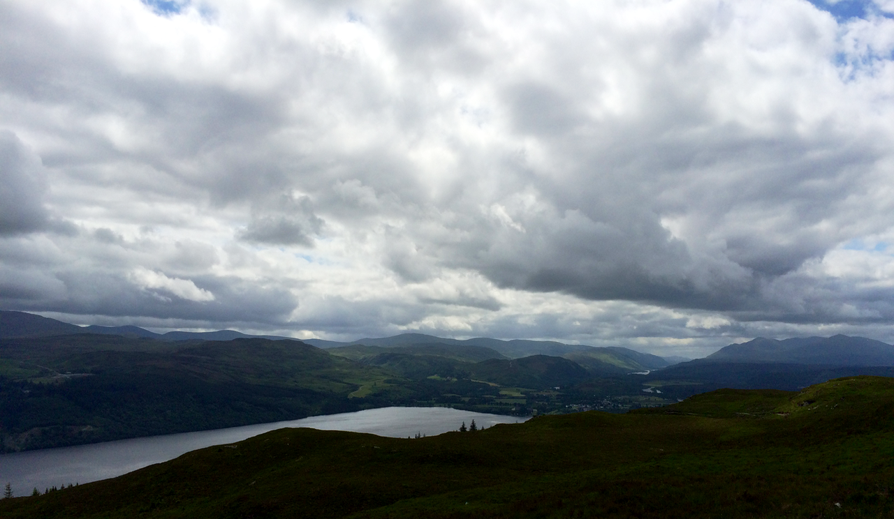 |
| The start of Loch Ness, with Fort Augustus at its head |
 |
| Looking along Loch Ness; it so vast, this is only a tiny part of it. |
Day 5 - Invermoriston to Drumnadrochit - 23 km
We had run into the Americans in the Glenmoriston Arms, and had a chat about the High Route between Invermoriston and Drumnadrochit. They'd heard that there wasn't much point suffering the climb, which is 422m, because the view is largely the same as the previous section, ie. Loch Ness from above. We also sat next to an Australian couple that night, who had lived in my hometown, and were old friends with my mother's next-door neighbour. I guess even in a hamlet in the Scottish Highlands, population 264, the Armidale six-degrees of separation persists.We decided to take the main Way, and that was a good decision. I didn't find the day overly enjoyable because my foot was troubling me from the moment we started out, and I was fixated on worrying about the 32km last day, so adding additional climbing uphill would have broken me.
Man, we were exhausted, and my foot and knee were so painful. Our topic of conversation for most of the 6 hours we were walking consisted mainly of, "I mean, if we start really early, and just keep going, not take many breaks, it will be ok." But my internal monologue went like this, "Oh my god, my foot. My toe. Maybe if I shift my foot up my shoe... nope. Oh god, we have another 6km to go. If I have to walk 32km tomorrow I will die." About 2 hours in, we started talking about alternative ways to make it through the last day. Like.. maybe we could hire kayaks? Or walk some of the way and get a bus....?
 |
| While I paused to take this photo, the Scouts passed us for the first time. |
On arriving in Drumnadrochit, we ran into a Scout troop that had looped past us about 5 times already, because even after taking the High Route they were faster than us. We arrived at our B&B, which was 2km out of town, only to find no one home and a sign on the door saying that the owner would be back at 4pm. We sat down on the driveway, despondent, and when 4pm came and went I started to get some bad feelings about the place. But then... we wondered, why did the note on the door have our room number? Was there perhaps another door out the back that we had missed? Rob went for a wander around the building, but there was nothing. And then... we tried the front door. It was open. Because in the Highlands, you can leave your house open and nothing bad will happen.
It turned out that Mary, the B&B owner, was a delight. I loved her. When I mentioned our serious reservations about the following day's walk and how we had joked about finding a boat, she said, "There's a ferry that goes from Urquhart Castle, up Loch Ness to Inverness. They don't advertise it. Do you want me to call them? I'll call them." And when she said, "I don't know how much it is," I said, "I do not care. Just book us two seats. I do not care if it costs one hundred pounds."
Day 5 - Drumnadrochit to Inverness - 32 km or an afternoon on a boat
Even with our diversions, and missed sections, we walked over 100km all told. |
| What struck me whilst we were walking, and I think it comes across in the photos, was how changeable the weather was. One minute we would have stunning blue sky and bright light, and then it would turn dark and we would get hit with a shower. Then, as quickly as it came, the shower would pass and be replaced by fluffy white clouds. |
 |
| Definitely rain on the way... |
We spent the day in Drumnadrochit, and at Urquhart Castle, and the afternoon on Loch Ness.
 |
| You can even see in this photo the rain in the distance, the darkness, the fluffy white clouds, and the blue sky. |
We arrived as the weather closed in, and we walked the final mile along the River Ness into Inverness.
 |
| And then the clouds lifted, and we got a beautiful summer sunset over the River Ness |
I ended up getting admitted to hospital that night in Inverness, and we were completely exhausted, but you know what? We made it, and it was f*cking awesome.
 |
| Bye bye Great Glen Way. We're going to try again, and next time we won't be beaten! |
❤


0 comments on this post
Leave a comment...you know you want to...